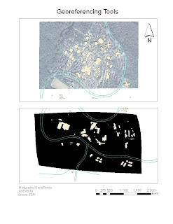
In this lab, we are georeferencing a unknown aerial to a known buildings and roads map. In order to do this, I added ten control points from the known maps to the georeferenced map or unknown map. After adding the ten points, I displayed data as a table in order to see how similar the two maps were in a 1st ordeer polynomial reference frame. In order to make sure the maps line up we are looking at the RMS or Residual Error. For the map to be a good fit, we are looking for a RMS of under 20. I was able to reduce this number through trial and error to 15.89071 on my maps. This seems to be a very good fit by visualization and the fact my RMS is low.
The second map is a raster map of the same general area.I used a third order polynomial reference frame. I had to use 21 different control points for this map. I got a RMS of 17.83217. A good fit for this size data set.
I don't know why the image is black. When I did the assignment it raster image was fine and matched up well. I even tried to reload the data to my map and it looked like this. I could not remedy the problem. Though you can see by the distortion of the map that it has been Georeferenced.

No comments:
Post a Comment