Tuesday, March 30, 2010
Week 10: Spring Break Lab
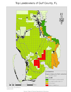
In this lab, We used raw data from tables which were created in ArcMap. We joined the data from the tables to already existing shapefiles.I then exported the data to become a new layer in ArcMAP. The last thing I did was categorize the data with the top 4 landowners of Gulf County, FL. By changing the background color of the layout, you can easily see each parcel and its owner, while leaving the other parcels owned by people or companies not in the top four a neutral color.
Tuesday, March 23, 2010
Map Overlays and Buffers
Question 1: Which tool did you use? Was there any noticeable difference in its result and the results from the instruction?
I used the Intersect Tool because the description of what the Intersect Tool seem to do is what is being asked of us.This seemed to work much faster and with no noticeable difference in its results. This tool work much quicker than all of the steps taken in the instructions.
Question 2: Which tool did you use here and Why?
I used the Erase tool becaquse we want to keep everything in our original area while getting rid of the aarea within the conservation areas so that the people and the plants are safe from harm.
Question 3: How many features are in this layer? What is the are of the largest feature? What is the are of the smallest feature?
I got 78 features. The largest area was 7765034.5 Square Meters. While the smallest feature was 748.1 Square Meters in area.
Wednesday, March 3, 2010
Week 8: Image Editing
This is the edited image of the University of West Florida. It is the same image that we worked with last week with a few edits. There is a new shapefile layer named Athletic_fields and Ihave digitized the Athletic Fields into this layer and displayed the layer in my legend. There are also edits to the building layers where the two building have been editied to fit the image. Also I digitized the maintenance road in the lower right portion of the image to the roads layer.
Subscribe to:
Posts (Atom)